


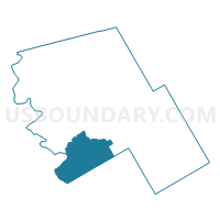
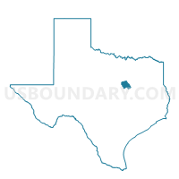
Voting District 0014, Hill County, Texas
About
Outline

Summary
| Unique Area Identifier | 674779 |
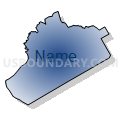
| Name | Voting District 0014 |
| County | Hill County |
| State | Texas |
| Area (square miles) | 84.63 |
| Land Area (square miles) | 83.17 |
| Water Area (square miles) | 1.47 |
| % of Land Area | 98.27 |
| % of Water Area | 1.73 |
| Latitude of the Internal Point | 31.82604590 |
| Longtitude of the Internal Point | -97.21479490 |
Maps

Graphs
Select a template below for downloading or customizing gragh for Voting District 0014, Hill County, Texas


Neighbors
Neighoring Voting District (by Name) Neighboring Voting District on the Map
- Voting District 0002, Hill County, TX
- Voting District 0007, Hill County, TX
- Voting District 0011, Bosque County, TX
- Voting District 0013, Hill County, TX
- Voting District 0016, Bosque County, TX
- Voting District 0065, McLennan County, TX
- Voting District 0067, McLennan County, TX
- Voting District 0081, McLennan County, TX
Top 10 Neighboring County Subdivision (by Population) Neighboring County Subdivision on the Map
- Hillsboro CCD, Hill County, TX (13,425)
- Whitney CCD, Hill County, TX (9,217)
- West CCD, McLennan County, TX (7,458)
- Clifton CCD, Bosque County, TX (7,357)
- China Spring CCD, McLennan County, TX (5,106)
Top 10 Neighboring Place (by Population) Neighboring Place on the Map
Top 10 Neighboring Elementary School District (by Population) Neighboring Elementary School District on the Map
Top 10 Neighboring Secondary School District (by Population) Neighboring Secondary School District on the Map
Top 10 Neighboring Unified School District (by Population) Neighboring Unified School District on the Map
- China Spring Independent School District, TX (10,962)
- Hillsboro Independent School District, TX (10,634)
- Whitney Independent School District, TX (9,739)
- West Independent School District, TX (7,992)
- Clifton Independent School District, TX (6,677)
- Valley Mills Independent School District, TX (3,390)
- Aquilla Independent School District, TX (1,310)
- Abbott Independent School District, TX (1,085)
Top 10 Neighboring State Legislative District Lower Chamber (by Population) Neighboring State Legislative District Lower Chamber on the Map
- State House District 10, TX (184,699)
- State House District 58, TX (169,146)
- State House District 56, TX (155,303)
Top 10 Neighboring State Legislative District Upper Chamber (by Population) Neighboring State Legislative District Upper Chamber on the Map
Top 10 Neighboring 111th Congressional District (by Population) Neighboring 111th Congressional District on the Map
Top 10 Neighboring Census Tract (by Population) Neighboring Census Tract on the Map
- Census Tract 9605, Hill County, TX (5,885)
- Census Tract 41.02, McLennan County, TX (5,106)
- Census Tract 9504, Bosque County, TX (3,703)
- Census Tract 9611, Hill County, TX (3,701)
- Census Tract 42.02, McLennan County, TX (3,690)
- Census Tract 9607, Hill County, TX (2,023)
Top 10 Neighboring 5-Digit ZIP Code Tabulation Area (by Population) Neighboring 5-Digit ZIP Code Tabulation Area on the Map
- 76705, TX (29,155)
- 76645, TX (11,039)
- 76692, TX (10,115)
- 76634, TX (7,093)
- 76691, TX (6,454)
- 76633, TX (4,973)
- 76621, TX (1,037)
- 76622, TX (1,015)